Update: rural internet access

s-internet-update-2009-04-20-1.JPG
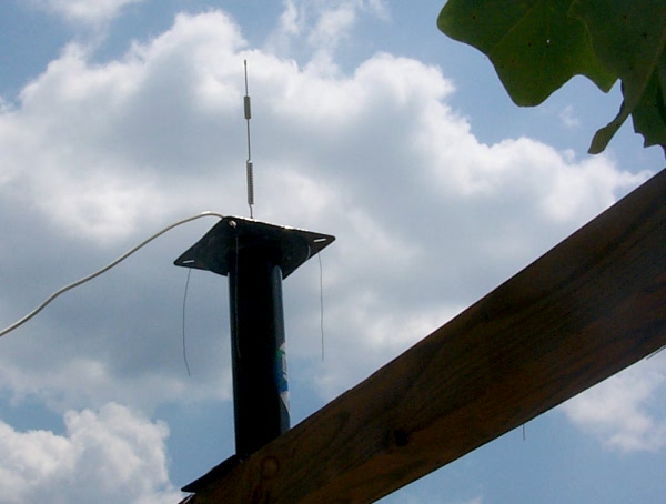
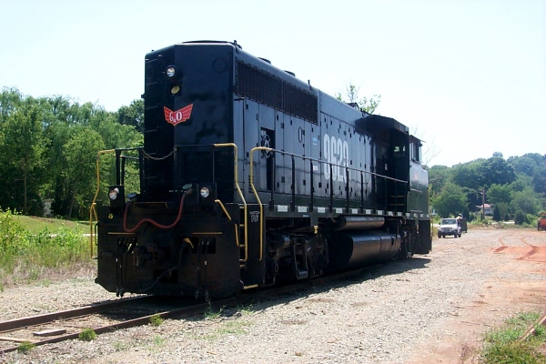
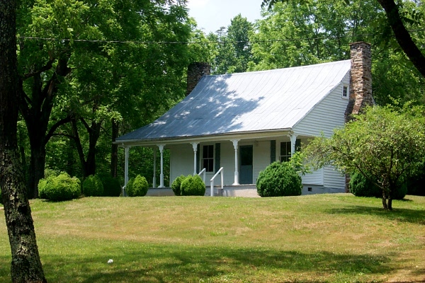
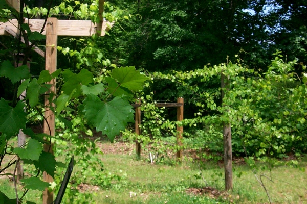
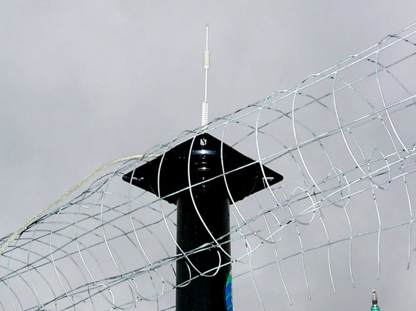
My internet antenna. It’s a 12-inch omnidirectional antenna. The fencing is a quick-and-dirty ground plane.

Last year I started using Alltel’s EVDO wireless system for internet access. I had a rough start with slow speeds, but after some nerdly noodling the system settled down and was pretty reliable, with typical download speeds of 500 kbps and typical upload speeds of about 90 kbps. This is not as fast as DSL, but here in rural America where we don’t have DSL, that was a pretty good speed.

Then, about a week ago, my speeds suddenly dropped from EVDO speeds to what is called “1x” speed — 130 kbps down and 40 or so kbps up. Very bad. When I called Alltel tech support, the tech told me that I had almost certainly been roaming to a Sprint tower for all those months, and that, because of the Verizon merger with Alltel, the roaming agreement with Sprint had ended. Now, he said, I would have to connect with an Alltel tower or a Verizon tower. All Alltel towers support 1x, but not all of them support EVDO.

On Sunday, tired of working on the new house, I decided to do some nerd work. I put a directional EVDO antenna on a portable mast and turned it in all directions, searching for a (possibly distant) tower that would give me EVDO speeds. I could get a 1x signal by pointing in almost any direction. In some directions I could detect a faint (-117 dBm) EVDO signal, but the signal was too faint to connect to. Disappointed, I reconnected the omnidirectional antenna that I’ve been using for months. I found that I could get a slightly stronger 1x signal if I improved the antenna’s ground plane by putting some metal fencing under the antenna. Slight improvements in antenna efficiency never do any harm.

To my surprise, about an hour later, I found that I was getting EVDO speeds again, better than the speeds I had all winter. I have no idea what changed.

Without accurate and up to date information on exactly where different carriers’ towers are located, and what data services are supported on those towers, making EVDO work out in the sticks is guesswork and voodoo. Plus I’ve never had an opportunity to talk with anyone who truly understands how cellular technology works. The employees of cell phone companies know nothing beyond “what PRL are you using.” At this point I have no idea whether I’m connected to an Alltel tower or a Verizon tower, or where that tower is. One of my nerdly rules is, if it’s working good, leave it alone. The high speed connection has been up for 14 hours. I hope I can hold on to it.

People think I’m weird because my cell phone (a Motorola M800 bag phone) weighs 10 pounds, and my data card (a Kyocera KPC680) has an outdoor antenna. But, here in the sticks, I would never consider buying a cell phone or a data device that can’t be connected to a proper outdoor antenna. The built-in antennas are pathetic and work well only when they’re close to a cellular tower.

internet-update-2009-04-20-2.jpg
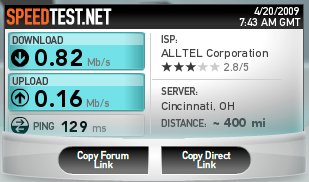
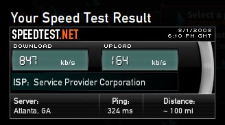
.82 Mb/s = 820 kbps. That would be a decent speed on DSL, and it’s a great speed for rural EVDO.

Coyotes in Carolina

coyote-immigation.jpg
North Carolina Wildlife Resources Commission

The cat woke up and make quite a fuss about 3 a.m. when she heard a pack of coyotes in the woods. It’s the first time I’ve heard coyotes in North Carolina. I’ve heard them before while camping in the mountains of California, near Yosemite. It’s a primitive sound — a spooky choir of high pitch yelps that sound as though they have to do with the final frenzy of hunting.

There’s a lot of lore and misinformation about coyotes in North Carolina, but I believe this article from the North Carolina Wildlife Resources Commission tells the story. Coyotes, it seems, have extended their range into North Carolina over the past couple of decades, and they’re here to stay.

Update on rural Internet access

womni-antenna.JPG
Omnidirectional vertical EVDO/cellular antenna

speed-report-8-011.jpg
DSL speeds!

For reasons I don’t really understand, I’m getting better EVDO performance with an omnidirectional antenna than with a directional Yagi antenna pointed at the nearest Alltel tower. Small improvements in antenna placement also have made a substantial improvement. The antenna wants to be high and in the clear (as opposed to perched on the roof of the trailer). The antenna also likes a metal base with ground-plane wires roughly the same length as the antenna. You can see the ground-plane wires dangling from the base of the antenna.

I now feel like I’m getting my money’s worth out of Alltel. I’m also getting a decent Internet experience, at last.

Today: stalking trains, tractors and lilies

wtrain-1-628.JPG
A diesel engine belonging to the Yadkin Valley Railroad stands idle on a sidetrack at Donnaha, right beside the Yadkin River. Yadkin Valley Railroad is a tiny railroad owned by Gulf and Ohio. It has two lines — one from Rural Hall to Mount Airy (48 miles), and another from Rural Hall to Elkin and North Wilkesboro (66 miles). Donnaha is on the Elkin/North Wilkesboro line. Rural Hall is in Forsyth County right on the Stokes County line.

wtrain-2-628.JPG
That white Jeep gets around.

wtrain-tractor-628.JPG
I’ve never seen a tractor I didn’t love. This one belongs to the railroad, and I have no idea what kind of work it does.

wlily-1-628.JPG
A day lily at Holden Gardens in Yadkin County. Holden Gardens raises a wide variety of day lilies. I put in an order for 300 fans of plain old roadside lilies. Holden Gardens is off Courtney-Huntsville Road about four miles from my mother’s place.

wlily-2-628.JPG
The homeplace at Holden Gardens.

wlily-3-628.JPG
The wellhouse at the Holden Gardens homeplace.

wlily-4-628.JPG
Day lilies with tractor at Holden Gardens

wlily-6-628.JPG
Day lily with beetle

wlily-7-628.JPG
One of the owner-operators at Holden Gardens

Road trip: The headwaters of the Dan River

wshire-like-scene-june-9.JPG
Near Westfield on N.C. 89

The Dan River begins in the foothills of the Blue Ridge Mountains in Virginia. The area includes Stokes and Surry counties in North Carolina and Patrick County in Virginia. I took a little road trip through this area today. It was hot, but I just couldn’t take another day of sitting inside with the air conditioning running. The Jeep has no air conditioner, but it’s nice and cool if you take the windows out and keep moving.

wwroute-june-9.jpg
The Dan River headwaters in Google Earth

wfarmstead-june-9.JPG
A farmstead near Claudville, Virginia

woutbuilding-june-9.JPG
Outbuilding near Claudville, Virginia

wcherries-june-9.JPG
A cherry tree near Claudville, Virginia

wwhite-church-june-9.JPG
A church near Claudville, Virginia

wtheology-june-9.JPG
Theological innovation near Westfield, North Carolina. If you can’t read it, the sign says “Chestnut Ridge Progressive Primitive Baptist Church.”

wacres-of-yard-art-june-9.JPG
Artistic innovation — a yard art factory near Mount Airy, North Carolina

wjewelweed-june-9.JPG
Butterfly weed near Claudville, Virginia

wbig-poplar-june-9.JPG
A majestic poplar, as big as an oak, near Francisco, North Carolina

wcottage-june-9.JPG
A cottage on Virginia Route 103

wcottage-2-june-9.JPG
A cottage on N.C. 8 near the Virginia line.

wbig-bales-june-9.JPG
Hay work is going on everywhere right now. With the price of grain sky high, the hay must be really valuable to the local farmers. These days, most of the hay goes into big, industrial-size bales.

wregular-bales-june-9.JPG
Still, some people still make old-fashioned hayride bales, and boys still learn how to do it.

wno-hayride-june-9.JPG
The big ones would be useless for hayrides!

A ride up Booger Swamp Road

wboog-swamp.JPG
Yes there is a Booger Swamp Road. I believe it’s in Zip Code 27055 if you want to Google it for yourself.

wyoung-tobacco-june3.JPG
Californians, here’s what young Carolina flue-cured tobacco looks like. This is the kind of tobacco that is made into cigarettes. This is on Center Road, one turn off Booger Swamp Road. I’ll try to show you more of the tobacco crop as the season progresses.

wfarm-machinery-june3.JPG
Here’s the farm machine du jour. I believe it’s a seed drill, and it’s probably out to plant soybeans. For some reason, I find farm machinery fascinating. This is on Shallowford Road near Lewisville. All three of these photos are in Yadkin County.

Today's photos, in no particular order

wtree-work-may29.JPG
The local power company, Energy United, has been clearing trees around the power lines up on Duggins Road. I stopped and had a nice chat with the two supervisors about going as easy on the greenery as possible. They were very nice and didn’t disagree at all. Part of what they’re doing, though, is an infrastructure upgrade. They’re getting ready to replace the old copper and steel overhead wiring with aluminum and steel wiring. They say that the new wiring is stronger, less likely to melt when something falls on it, and has lower electrical resistance.

wstrawberries-may29.JPG
The local strawberries are in. These were in a produce market at Walnut Cove, and they told me the berries were grown in Madison.

wsickle-1-may29.JPG
In the agricultural history department, this old sickle caught my eye. It’s beside the main drag in Walnut Cove.

wsickle-2-may29.JPG
It’s meant to be pulled by a mule. It takes power from a rear wheel, and, through a shaft and cam, converts the wheel’s motion to reciprocal motion to drive the sickle. This machine was made by B.F. Avery & Sons Co., in case anyone is doing a web search on old machinery.

wsickle-3-may29.JPG
The sickle

woldhouse-1-may29.JPG
Abandoned homeplaces are always fascinating. There are lots of them around here, and we take them for granted. But they can’t be common everywhere. I would imagine it takes certain trends and circumstances to create abandoned homesteads, things like cheap land, changing technology, more suburbanized ways of making a living, migration patterns, and so on. In short, not many people want to live that way anymore, and the places aren’t worth keeping up. It’s a shame.

woldhouse-2-may29.JPG
Old houses are a repository of vanishing culture. They’re also a repository of heirloom varieties of flowers, shrubs, and fruit trees. This particular old house, on Stewart Road on the way to Walnut Cove, has two huge growths of roses, one pink, one deep red. The front porch is large and is still there, but it’s been taken by overgrowth.

woldhouse-3-may29.JPG
An overgrown outbuilding. It’s all so art nouveau.

woldhouse-4-may29.JPG
Honeysuckle everywhere. Right now you can drive for miles and miles on the backroads and never leave the scent of honeysuckle.

woldhouse-5-may29.JPG
Irises by the kitchen window

woldhouse-6-may29.JPG
Old roses…

woldhouse-7-may29.JPG
Can you find the chimney?

The miracle of May

wtruck-swallowed-up.JPG
Mountain View Road, Stokes County, May 23. This is the kind of grass I want — deep, unmowed grass that swallows pickup trucks. Note the color of the sky close to the horizon. That is Carolina blue.

wroses-2-may-23.JPG
More of Mama’s roses, May 23, Yadkin County. The amazing thing is, these blooms had not even started opening last week when I was there.

wroses-1-may-23.JPG
… and still more of Mama’s roses. By the way, the person who has done all the work of gardening on this old place for the past three years, and who has done a just remarkable job, is my sister’s husband, Graham. The older buildings and the homeplace are almost gone, and the land has been divided up, but the land upon which theses roses are growing has been in the family for at least four, if not five, generations. This rose bush, however, is only three years old.

From Mama's house to my house

w-m17-01-mamas-roses.JPG
Mama’s roses

All these photos were taken yesterday. I let the GPS device pick a route from Mama’s house to my place in Stokes. I told the GPS device to pick a route that led past a particular place along the Yadkin River where I’d remembered seeing an old mill 30 years ago, and I told it to stay off the main roads. What a route! I knew some of the roads, but others were completely new to me. This was an amazingly scenic route that just happened to lead past the places where parts of three movies were filmed: Junebug (Pinnacle, Stokes County), Cabin Fever (Priddy’s General Store, Stokes County), and Leatherheads (Donnaha, Yadkin County). This area is rich in agricultural history. More posts on agricultural history another day. It took me along the foot of Pilot Mountain. The route also led past two old Stokes County resorts — Vade Mecum and Moore’s Springs — and it took me past the entrance to Hanging Rock State Park, not to mention downtown Danbury (the Stokes county seat) and Priddy’s General Store, where I stopped to get a Cheerwine and say hello to Jane Priddy-Charleville, who runs the store. It took me past a winery that I was not previously aware of, about which I’ll post another day.

w-m17-02mamas-grapevines.JPG
Mama’s young grapevines

w-m17-03-mill-1.JPG
The mill on the Yadkin

w-m17-04-mill-2.JPG
Machinery in the mill on the Yadkin

w-m17-05-mill-3.JPG
More of the mill on the Yadkin

w-m17-06-mill-4.JPG
Cogwheel at the mill on the Yadkin

w-m17-07-mill-5.JPG
Cadillac in the barn by the mill on the Yadkin

w-m17-08-mill-6.JPG
The hardworking owner of the mill on the Yadkin

w-m17-09-moores-springs-1.JPG
Moore’s Springs, Stokes County

w-m17-10-pilot-mountain-1.JPG
Pilot Mountain

w-m17-11-vade-mecum-1.JPG
Vade Mecum (Stokes County), now a summer camp

w-m17-12-vade-mecum-2.JPG
The road to Vade Mecum

w-m17-13-homestead-1.JPG
A Yadkin Valley homestead

w-m17-14-homestead-2.JPG
Another Yadkin Valley homestead

w-m17-15-dogs-1.JPG
Residents of a Yadkin Valley homestead

w-m17-16-priddys-1.JPG
Security guard at Priddy’s General Store

w-m17-17-priddys-2.JPG
Priddy’s General Store

w-m17-18-priddys-3.JPG
The owner of Priddy’s General Store

w-m17-19-farm-machine-1.JPG
How they did it then

w-m17-20-farm-machine-2.JPG
How they do it now

w-m17-21-farm-machine-3.JPG
How they did it then again

Finding country roads, with technology

wgps-country-road.JPG
The backroad to Germanton

I’ve always loved the backroads, and I thought I knew the backroads around here. But nothing knows the backroads like a GPS device.

I’ve had a hiker’s GPS unit for years, but it’s not smart enough to plot over-the-road routes and tell you where to turn. I’ve played with those things occasionally in rental cars, but they’re too complicated to learn how to use in a rent car. But last week I broke down and got me** a remaindered Garmin iQue M5 on eBay.

It got me*** to Madison easily. I had not previously been to Madison from here because I didn’t know how to get there. I also let the GPS device plot a new route to Mama’s house in Yadkin County. It found a backroads way that I would never have thought to try, and it cut two to four miles off the distance. If you accidentally or intentionally stray off the route, the device will warn you, recalculate a new route, and talk you back toward your destination. Often I’ve avoided trying backroads because I had no map, had no idea where the roads went, and I didn’t want to risk getting too lost. But an in-car GPS device frees you up to explore with confidence.

Within the next few weeks, I’m planning a road trip into the mountains along the Tennessee/Virginia line. I’m going to explore me** some backroads.

** Californians: Google “reflexive dative,” or see this or this. Don’t y’all miss my little seminars on Appalachian English?

*** This is not a reflexive dative but is rather a simple indirect object. 🙂